Report on Mapping Technologies in Coral Reef Environments 10-19th March 2019 (Submarine Geomorphology WG)
Final Report on the Mapping Technologies in Coral Reef Environments Training Course 10-19th March 2019
Organised by the Submarine Geomorphology Working Group in collaboration with MaRHE centre – Magoodhoo, Faafu Atoll, Republic of Maldives.
Objectives of the Course
The aim of the course was to provide training to eleven participants, hailing from Italy, India, Hong Kong, Australia and the Maldives, on techniques used to map and collect geomorphological data in coral reef environments.
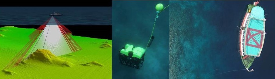
Daily activities spanned from the acquisition, processing and interpretation of terrestrial data with an Unmanned Aerial Vehicle (UAV) platform and the use of Structure from Motion (SfM) photogrammetry to generate DEMs and orthophotos, acoustic seafloor data (i.e.: bathymetry and backscatter using a shallow water multibeam echosounder), sediment samples and underwater videos (using a Remote Operated Vehicle (ROV)), as well as the generation of bionomic transects.
The final goal of the training course was for the students to be able integrate the above data in a GIS environment and generate a fine-scale 3-dimensional representation of coral reefs and associated landforms.
The course was organised by the International Association of Geomorphologists’ Working Group on Submarine Geomorphology in collaboration with MARHE centre (Magoodhoo, Faafu atoll, Maldives). The aim of the working group is to establish submarine geomorphology as a field of research and promote an exchange of ideas and techniques between terrestrial and marine geoscientists.
The training course on mapping technologies in coral reef environments was part of the working group’s efforts to disseminate state-of-the-art techniques used by submarine geomorphologists among students and professionals.

Instructors
The course was organised and delivered by the Submarine Geomorphology Working Group’s chairpersons, with the support of MaRHE (Marine Research and High Education) centre and University of Milano-Bicocca staff:
Alessandra Savini – Marine geologist and geomorphologist, MaRHE centre – University of Milano-Bicocca, Dept. of Earth and Environmental Sciences, Milan, Italy
Aaron Micallef – Marine geologist and geomorphologist, Marine Geology & Seafloor Surveying, Department of Geosciences, University of Malta, Malta
Sebastian Krastel – Marine geologist and geophysicist, Marine Geophysics and Hydroacoustics, University of Kiel, Germany
Fabio Marchese – Geomorphologist and marine geophysicist, University of Milano-Bicocca, Dept. of Earth and Environmental Sciences, Milan, Italy
Luca Fallati – Eco-geomorphologist, University of Milano-Bicocca, MaRHE centre, Dept. of Earth and Environmental Sciences, Milan, Italy
Course Activities
The course involved 9 days of intensive activities, covering more than 80 hours of hands-on activities in the field and laboratory that were integrated with lessons in the classroom. The lessons were held at the Marine Research and High Education Centre (MaRHE Centre) of Milano-Bicocca University in Magoodhoo Island, Faafu Atoll (Maldives). All field activities were carried out on board a traditional dhoni (wooden sailing vessel used in Asia). Laboratory activities included the use of dedicated software (i.e.: ArcGIS, Agisoft Photoscan, Qimera, Qinsy, Fledermaus, Agisoft, Gradistat, SedLog and others) for processing, visualising and interpreting collected data, as well as sedimentology exercises.
At the end of the training course, the students were able to:
– Plan a geomorphological survey in coral reef environments
– Collect, process and interpret terrestrial and submarine topographic data using a wide range of technologies and software packages (UAV, multibeam echosounder, ROV, bionomic transects and sediment sampling)
– Integrate multi-scale terrestrial and marine data in a GIS environment and generate DEMs
– Identify the main carbonate producers in coral reef environments
List of Participants
- David Richard Blakeway – Consultant, Fathom 5 Marine Research, Lathlain, Australia
- Marco Biagini – BSc student, University of Milano-bicocca, Milan, Italy
- Marina Cuselli – MSc student, University of Milano-bicocca, Milan, Italy
- Francesca Dajma – BSc student, University of Milano-bicocca, Milan, Italy
- Nishtaran Fathimat – Lecturer, National University of Maldives, Male, Maldives
- Francesca Giovenzana – , MSc graduate, University of Milano-Bicocca, Milan, Italy
- Kumar Gaurav – Assistant Professor, Indian Institute of Science Education and Research Bhopal, India
- Pui Ling Lau – MSc graduate, Agriculture, Fisheries and Conservation Department, Hong Kong – China
- Gabriele Mandelli – BS student, University of Milano-bicocca, Milan, Italy
- Rachele Napolitano – PostDoc, Marche Polytechnic University, Ancona, Italy
- Andrea Giulia Varzi – MSc student, University of Milano-bicocca, Milan, Italy
Detailed Programme
DAY 1 – 10th March 2019
- Arrive in Male and transfer to Magoodhoo
- 14:30 Lunch in Magoodhoo
- 15:30 Welcome briefing
- 16:00 LESSON 01: Geomorphology of coral atolls and (Maldivian) coral reef zonation
- 17:00: short visit of the island
- 18:00: sunset tea time
- 19:30: Dinner
- 20:30 LESSON 02: Geomorphological mapping in coral reef environment: a short overview on methods and techniques
- 21:00 LESSON 03: Georeferencing the data for geomorphological mapping: GPS, cartography and GIS
- 21:45 briefing on next day activities
DAY 2 – 11th March 2019
- 07:30 breakfast
- 08:30 FIELD activity 01: Excursion and topographic survey
- 11:00 snorkelling ability test
- 12:30 lunch
- 13:30 LAB activity 01: Software installation – GPS data processing and planning of a cartography project in ArcGIS
- 17:00 Coffee time
- 17:30 LESSON 04: Non-destructive sampling methods in coral reef environments
- 18:30 LESSON 05: Remote sensing and coral reef
- 19:30 Dinner
- 20:30 briefing about next day’s activities
DAY 3 – 12th March 2019
- 07:30 breakfast
- 08:30 FIELD activity 02: Georeferenced bionomic transects – snorkelling on the inner reef
- 12:30 lunch
- 13:30 LAB activity 02: Data Processing (bionomic transects) and implementation of results into the GIS project. Integration of satellite data.
- 16:00 LESSON 06: Monitoring Coral Reef environments with drones (UAV).
- 16:30 positioning of Ground Control Points for next day’s UAV data collection
- 18:00 Coffee time
- 18:30 LESSON 07: Collecting elevation data in coral reef environment: issues and challenges
- 19:30 Dinner
- 20:30 briefing about next day’s activities
DAY 4 – 13th March 2019
- 07:00 FIELD activity 03: UAV survey
- 07:30 breakfast
- 08:30 Recovery of ground control points
- 09:30 LESSON 08: Photogrammetry and Structure from Motion technique
- 10:30 LAB activity 03: Processing UAV data: software installation (Agisoft-Photoscan®)
- 12:30 lunch
- 13:30 LAB activity 04: UAV data processing (Application of Structure from Motion technique)
- 16:00 LAB activity 05: implementation of results from UAV data processing into the GIS project
- 17:00 Coffee time
- 17:30 LESSON 08: Acoustic remote sensing in coral reef environment: Multibeam Echosounders (MBES)
- 18:30 LESSON 09: Geomorphometry and spatial analyses
- 19:30 Dinner
- 20:30 briefing about next day’s activities
DAY 5 – 14th March 2019
- 07:30 breakfast
- 08:30 FIELD activity 04: Training on Navigation system and MBES survey – lagoon
- 12:30 lunch
- 13:30 LAB activity 06: Processing of MBES data: software installation (Qimera – QPS) and MBES data processing
- 17:30 Coffee time
- 18:30 LESSON 10: Acoustic remote sensing in coral reef environment: backscattering, side scan sonar & high resolution (shallow water) reflection seismic
- 19:30 Dinner
- 20:30 briefing about next day’s activities
DAY 6 – 15th March 2019
- 07:30 breakfast
- 08:30 FIELD activity 05: Training on MBES survey – inner reef
- 12:30: lunch
- 13:30 LAB activity 07: Backscattering data processing
- 16:30 LAB activity 08: Implementation of results (DTM) from MBES data processing into the GIS project and selection of sampling/ROV sites
- 17:00 Coffee time
- 17:30 LESSON 11: ROV & Sampling Methods
- 19:30 Dinner
- 20:30 briefing about next day’s activities
DAY 7 – 16th March 2019
- 07:30 breakfast
- 08:30 FIELD activity 06: Core sampling
- 09:30 Visit on an inhabited island and FIELD activity 07: ROV dive
- 13:30 Lunch and snorkelling on the island
- 18:30 Arrive in Magoodhoo & coffee time
- 19:30 Dinner
- 20:30 briefing about next day’s activities
DAY 8 – 17th March 2019
- 07:30 breakfast
- 08:30 FIELD activity 07: ROV survey (inner slope – Magoodhoo)
- 12:30 lunch
- 14:00 LAB activity 10: Extraction of the ROV survey track and implementation in the GIS project
- 16:00: LAB activity 11: Sediment analysis – granulometry, optical microscopy and core description
- 17:30 Coffee time
- 18:00 LESSON 11: Habitat Mapping: principles and techniques
- 19:00 LESSON 12: visual survey and video analysis for habitat mapping purposes
- 19:30 Dinner
- 20:30 briefing about next day’s activities
DAY 9 – 18th March 2019
- 07:30 breakfast
- 08:30 LAB activity 11: Integration of results into the GIS project
- 10:00 LAB activity 12: Characterisation of abiotic component in coral reef environment through integration of video, sediment samples and seafloor mapping data
- 12:30 lunch
- 14:30 Generation of a multi-scale geomorphological map of the surveyed areas and final discussions
- 19:30 Dinner
DAY 10 – 19th March 2019
- 09:00 Departure from Magoodhoo to Male Airport
Acknowledgments
The IAG Submarine Geomorphology working group thanks all participants for their enthusiasm and dedication, which made the course a unique opportunity to practise and learn mapping techniques for coral reef environments in a pleasant and relaxed environment.
The success of the course was also a result of the support of the director of the MaRHE centre Paolo Galli, the administrative manager of the MaRHE centre Anna Marchetti, all Maldivians that provided their assistance at the centre and during field work (in particular the captain of the dhoni Abduratman Siragiu), the head of the Magoodhoo council Abdullah Waheed and member of the council Ibrahim Zuhoor, and the great work done by Fabio Marchese and Luca Fallati. NEOSAIR, Socotec GeoMarine, QPS Netherlands are gratefully acknowledged for sponsoring the course.